

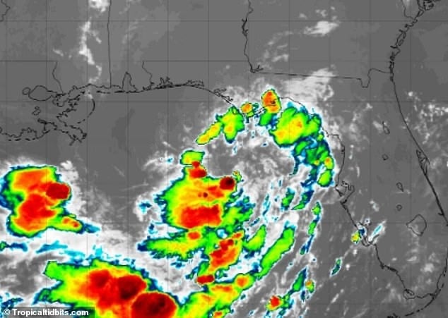
Forecasters expect Tropical Depression Two to strengthen into Tropical Storm Bertha within hours, threatening the Gulf Coast with heavy rain, dangerous seas and possible flash flooding as it tracks toward New Orleans.
A tropical storm is expected to form along the US Gulf Coast within hours, with millions of Americans across five states bracing for potentially life-threatening conditions. The National Hurricane Center has already designated the system Tropical Depression Two, and forecasters anticipate it will strengthen into a named storm, Tropical Storm Bertha, as early as Monday afternoon once wind speeds exceed 39 mph. The system is currently on a track that could bring it directly to New Orleans by Wednesday afternoon, with heavy rain and sustained winds above 50 mph expected across the Florida Panhandle, Mississippi, Alabama, Louisiana and Texas.
Current position and forecast
As of Monday morning, Tropical Depression Two had maximum sustained winds of around 30 to 35 mph and was located roughly 155 miles south of Panama City, Florida, moving slowly to the north-northwest. The National Hurricane Center has issued a Tropical Storm Watch for parts of the Florida Panhandle, stretching from the Ochlockonee River to the Florida-Alabama border, where tropical-storm conditions are considered possible within the next 36 to 48 hours.
Forecasters say storm surge of one to three feet is possible along parts of the northern Gulf Coast should the system strengthen into Tropical Storm Bertha as expected. The National Hurricane Center noted that dry air and wind shear are currently limiting the system’s development, though environmental conditions could become more favourable for strengthening in the coming days. Hurricane Hunter aircraft are flying into the system to gather data that will help refine forecasts of its track and intensity.
Risks to coastal communities
Dangerous seas and waves of up to 16 feet could threaten boats and beachfront communities this week as the system moves from east to west across the Gulf. Tropical storm warnings have already been issued along the entire Florida coastline, from Tallahassee to Miami, by the National Weather Service, with officials warning the storm could “capsize or damage vessels.” Up to eight inches of rain are forecast for several areas, including Tallahassee and Panama City in Florida, as well as New Orleans, home to nearly one million people across its seven-parish metropolitan area.
Uncertainty remains over track and intensity
Forecasters have stressed that significant uncertainty remains around the storm’s projected path, warning that relatively small shifts in track could have a major impact on which Gulf Coast communities bear the brunt of the worst weather. Even if the system remains comparatively weak, meteorologists have warned it could still produce dangerous rip currents, coastal flooding and life-threatening flash flooding due to prolonged heavy rainfall.
AccuWeather meteorologist Tyler Roys said: “Tropical systems can bring dangerous rainfall, flash flooding, and other hazardous impacts regardless of whether they receive an official designation.”
